Geography homework
fairlight ideas planningAs part of my planning to (hopefully) make Fairlight look like a convincing preserved railway I’ve been putting some thought into where the line might have run, had it actually existed. By getting a feel for the length and age of the railway and the types of industries it served this should help to give an idea of what facilities would have been required at the terminus or other interchange points.
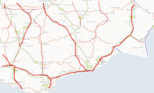
This is a sketch of the real railway network in East Sussex (and western Kent). The bolder red lines are those still operating, the rest were mostly closed by the end of steam (preserved lines excepted) but in the context of my narrow gauge railway being built this would have been the landscape at the time. The blue lines are real narrow gauge / miniature railways – the Rye and Camber Tramway (3′ gauge / 1895) and the Romney Hythe & Dymchurch Railway (15″ gauge / 1927). The real Fairlight is a small village in the high ground just to the east of Hastings, but for my purposes it has become a larger town more accessible to the sea, taking on elements of Rye and Hastings old town.
So the problem is, where could another line fit in to an already fairly dense network? I wanted to incorporate a stretch of coastal running, inspired by the tramway at Pett Level used in the construction of sea defences, which suggested I would need to go east from Fairlight but once you get beyond Rye settlements are sparse and unlikely to sustain another railway aside from the Ashford – Hastings (Marshlink) route. So the “Fairlight Railway” would most likely have to turn inland, towards the more populous regions of East Sussex.
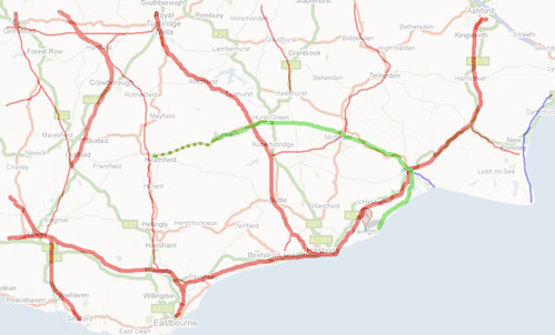
This gives my initial option for the route, which runs from Fairlight along Pett Level to Winchelsea and Rye and then turns north west towards the Kent & East Sussex Railway at Northiam. For now I am “joining the dots” rather than looking in detail at routes through the terrain, but things are fairly flat around here. From the K&ESR junction we continue up to Hurst Green and then the Tonbridge – Hastings line around Etchingham, exploiting a general lack of east-west lines across the heart of the Weald to reach the attractive town of Burwash where I pictured development of the railway might have ground to a halt as the lie of the land becomes more difficult – but with original aspirations to a junction with the Cuckoo line* at Heathfield.
This of course fits the railway in around the real network, but once the modeller’s licence is in use there’s always the temptation to push things on a little further.
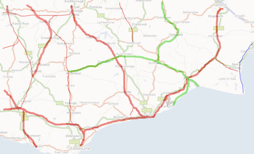
If we consider that the “Fairlight Railway” (I haven’t settled on a name for the line yet) predated the initial phases of the Kent & East Sussex (constructed 1900 – 1905), it becomes likely that it could have altered the course – and gauge – of that line. In fact the K&ESR was originally projected to run on to Maidstone in the north, and have a branch to Rye, so it doesn’t take an awful lot of effort to bind the two together and come up with something like the map above which is on the way to creating a little network of narrow gauge secondary routes. This is in effect a variation on the High Weald Light Railway, an 0-16.5 layout which was the nucleus of the inspiration for this project, but giving prominence to a ‘main line’ from Rye through Hurst Green to Heathfield. The potential for small, meandering branches of varying success off this core route is endless!
So with some thought given to how my railway might have fitted in to this part of the world, next on the list is to come up with how and when it was built, and what it was for.
* I’ve found exactly one reference online to the Cuckoo line originally being proposed as 3′ gauge, anyone know of any more detail on this?